Pioneering Marine Exploration with

Blue Marine Echosounder

The Blue Marine Echosounder is a cutting-edge solution designed for professionals in marine surveying, environmental monitoring, and coastal management. Equipped with state-of-the-art sonar technology, it offers unparalleled accuracy in underwater depth measurement and sediment analysis.

The Blue Marine Echosounder proudly stands as Indonesia’s first bathymetric echosounder with a TKDN certification exceeding 25%, combining local excellence with global technology standards.

High Performance

Bathimetric with RTK or PPK high accuracy GNSS.

40 Working Hours

Industrial Lifepo4 battery for working along day without worries.

IoT Ready

Stream data to TGIS dashboard realtime using cloud technology.

Lest talk about features

Keys & Main Feature

Blue Marine Echosounder represents the forefront of marine surveying technology. With its unmatched precision, robust design, and versatile applications, it’s the ideal solution for professionals seeking accurate and reliable underwater data.

Transducer type: Single Beam
Transducer Freq: 200 Khz
Depth Max: 200 m
Depth Precission: 0.01 m
Temperatur Precission: 0.05 C

CPU: Core i3 Quad Core
Internal: 16 Gb
Internal: 512 Gb

GNSS type: Multi Frequency GNSS with 184 Channel, GPS L1C/A L2C, GLO L1OF L2OF, GAL E1B/C E5b, BDS B1I B2I, QZSS L1C/A L2C.
GNSS Convergence time: RTK <10 sec.
Nav. update rate:
RTK up to 20 Hz1.
GNSS Position accuracy: RTK 0.01 m + 1 ppm.
Survey: Static, RTK Radio, RTK NTRIP, Navigation DGPS.

Indonesia TKDN: >25%.

  • Coastal Management: Leverage precise bathymetric data to support informed policy-making, coastal erosion prevention, and shoreline protection strategies. The Blue Marine Echosounder ensures accurate data collection for sustainable development.
  • Environmental Monitoring: Monitor sediment transport patterns and assess ecological changes in aquatic systems with precision. The device aids in understanding environmental dynamics and implementing effective conservation measures.
  • Port and Harbor Development: Ensure safe navigation, efficient dredging, and strategic construction planning for ports and harbors. With its high-accuracy capabilities, the Blue Marine Echosounder supports critical infrastructure projects.
  • River Engineering: Facilitate dredging operations and jetty construction with precise data on river depths and sediment layers. This ensures optimal designs and improves long-term structural integrity.
  • Hydrological Studies: Contribute to groundbreaking scientific research with reliable underwater mapping. The echosounder’s advanced capabilities support studies on hydrological changes, water resource management, and aquatic habitat mapping.

Blue Marine Echosounder

Advanced Technology for Precision Bathymetry and Sediment Analysis

Revolutionizing Marine Surveying Discover the next generation of underwater exploration with the Blue Marine Echosounder. Designed to deliver unparalleled accuracy, this advanced technology sets a new benchmark in bathymetric and sediment analysis. Whether you are managing coastal projects, monitoring environmental changes, or conducting hydrological studies, Blue Marine Echosounder is your ultimate partner for precision and reliability.

Innovative Technology for Modern Challenges At the heart of Blue Marine Echosounder lies cutting-edge sonar technology. Engineered to perform seamlessly in diverse marine conditions, it enables professionals to access high-quality data for informed decision-making. From shallow waters to deep-sea environments, this device adapts to every challenge with unmatched efficiency.

Transforming Marine Operations Blue Marine Echosounder not only simplifies complex surveying tasks but also enhances operational productivity. Its integration with leading software platforms and unmanned systems makes it a versatile solution for a wide range of applications. Experience the difference in marine data collection with a tool built to exceed expectations.

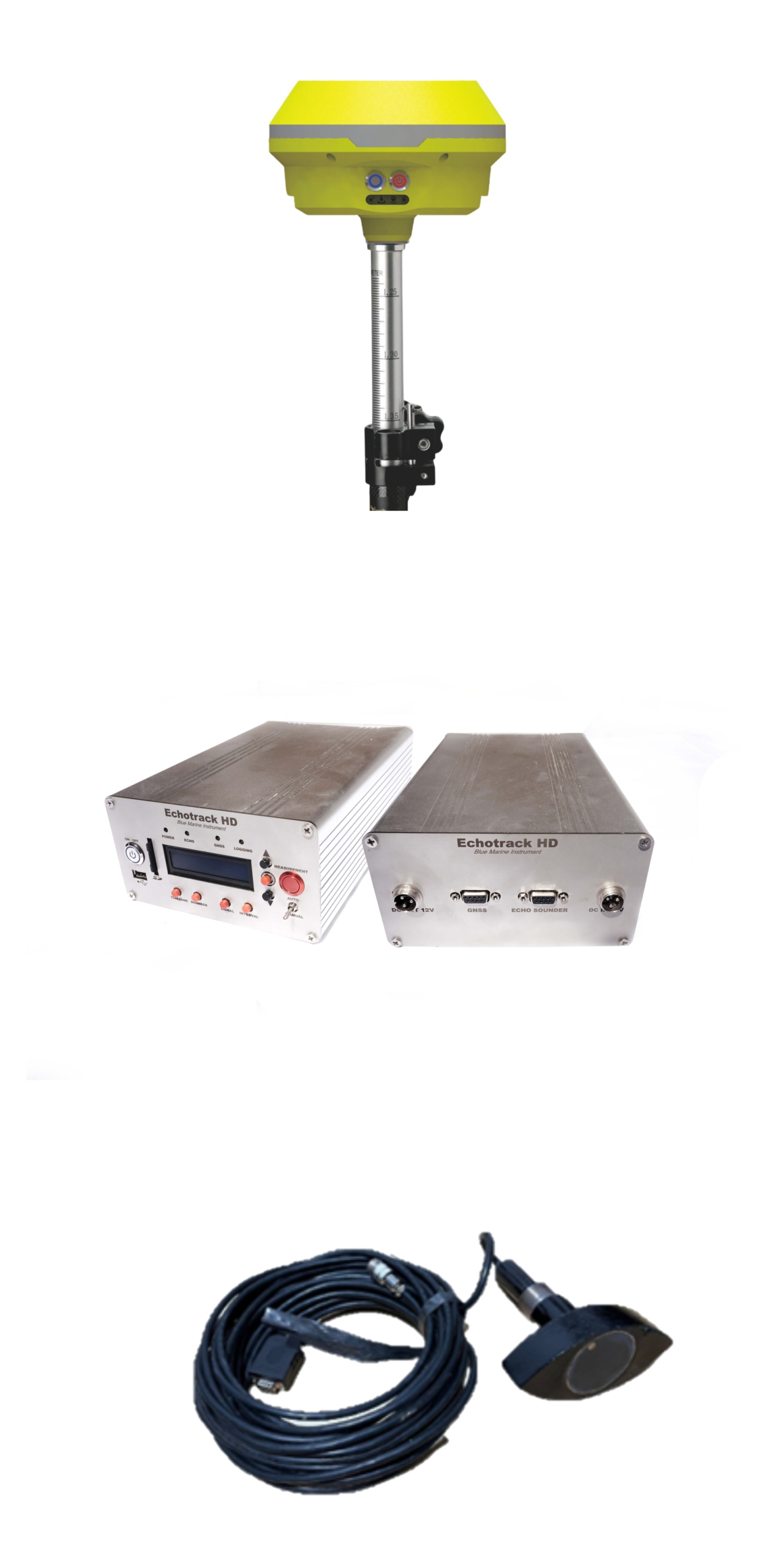
1
2
3
4
1

GNSS Reciever

2

Echotrack HD Front

3

Echotrack HD Module Back

4

Transducer

BLUEMARINE ECHOSOUNDER
Tranducer Bluemarine
Sensor Single Beam Echo Sounder
Beam Angle
Frequency Band 200 kHz
Minimum Depth 0.4 meter
Maximum Depth 200 meter
Depth Accuracy 99.46 %
Interval Output 0.1 to 25 Second / Interval
Sensor Tranducer, Compass, Gyroscope, IMU, GNSS
Data
Depth Display Resolution 0.01 meter
Data Output Depth, Temperature, Coordinate,Time
NMEA 0183 Baudrate 4800
Data Format RAW Data (.bmi format)
Connectivity and Indicator
Connectivity USB 3.0, RS232, SD Card,
Indicator Indicator Transmitter GNSS Data Indicator Transmitter Data Echosounder Indicator Logging (Record Data) Indicator Power
Power Input Voltage 9 to 16 VDC (Up to 10.000 mAh)
Software
Software Blue Marine Hydro
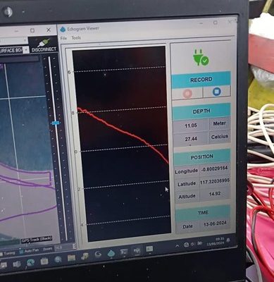
Display Depth Data Coordinate Data Temperature Data Echogram Data Time Accusistion
GNSS Support TGS Series GNSS Geodetic Dual Frequency
Size Unit
Dimensions 250mm x 165mm x 85mm
Weight 1420 gram
TKDN (Tingkat Komponen Dalam Negeri) Certificate Indonesia 38 %

Experience a new era of underwater exploration with the Blue Marine Echosounder. Engineered for unmatched accuracy, this state-of-the-art technology sets a new standard in bathymetric and sediment analysis. Whether managing coastal projects, tracking environmental changes, or conducting hydrological research, the Blue Marine Echosounder is your trusted partner for precision and dependability.

At the core of the Blue Marine Echosounder lies advanced sonar technology, designed to perform flawlessly across a range of marine environments. This device empowers professionals with high-quality data for informed decision-making. From shallow coastal waters to the depths of the ocean, it adapts seamlessly to every challenge with unparalleled efficiency.

  • Coastal Management: Leverage precise bathymetric data to support informed policy-making, coastal erosion prevention, and shoreline protection strategies. The Blue Marine Echosounder ensures accurate data collection for sustainable development.
  • Environmental Monitoring: Monitor sediment transport patterns and assess ecological changes in aquatic systems with precision. The device aids in understanding environmental dynamics and implementing effective conservation measures.
  • Port and Harbor Development: Ensure safe navigation, efficient dredging, and strategic construction planning for ports and harbors. With its high-accuracy capabilities, the Blue Marine Echosounder supports critical infrastructure projects.
  • River Engineering: Facilitate dredging operations and jetty construction with precise data on river depths and sediment layers. This ensures optimal designs and improves long-term structural integrity.
  • Hydrological Studies: Contribute to groundbreaking scientific research with reliable underwater mapping. The echosounder’s advanced capabilities support studies on hydrological changes, water resource management, and aquatic habitat mapping.

Why Choose Blue Marine Echosounder? Blue Marine Echosounder represents the forefront of marine surveying technology. With its unmatched precision, robust design, and versatile applications, it’s the ideal solution for professionals seeking accurate and reliable underwater data.

All documents may you need

Documentation

The Blue Marine Echosounder product documentation provides a comprehensive guide to understanding and utilizing this cutting-edge bathymetric tool. It includes detailed technical specifications, operational instructions, and maintenance guidelines to ensure optimal performance in diverse marine environments. The documentation also covers system compatibility, troubleshooting tips, and integration capabilities with other survey equipment. With clear illustrations and step-by-step procedures, users can confidently deploy the device for applications such as coastal mapping, sediment analysis, and hydrological studies


No Details Date Type
1 Manual Books  20/12/2024 pdf
2 Feature Eksplanation 21/12/2024 pdf
3 Design and Technology 22/12/2024 pdf
4 Research Publication 23/12/2024 pdf
5 Certificate Calibration 24/12/2024 pdf
6 Result of Calibration 25/12/2024 pdf
7 Sampel Data Location 1 25/12/2024 pdf
8 Sampel Data Location 2 25/12/2024 pdf
9 Sampel Data Location 3 25/12/2024 pdf
10 Blue Marine Hydro Data Collector 25/12/2024 exe
11 Blue Marine Post Processing Software 25/12/2024 exe

Blue Marine Echosounder First Case

Bathymetry Survey for Reservoir Sedimentation

he Blue Marine Echosounder excels in conducting bathymetry surveys to monitor sedimentation in reservoirs. By providing precise data on sediment layers and depth changes, it helps in planning sediment removal and maintaining reservoir capacity for optimal performance.

Advanced Coastal Monitoring

Coastal Line Bathymetry Survey

Gain valuable insights into coastal dynamics with Blue Marine Echosounder. It accurately maps underwater terrain along coastlines, assisting in erosion, habitat preservation, and shoreline protection projects.

3D Construction and Planning

Harbor Bathymetry Survey

Ensure the safety and efficiency of harbor operations with detailed bathymetric surveys. The Blue Marine Echosounder delivers precise depth measurements and sediment profiles, supporting dredging operations and port development.

Smart Construction and Mining

River Bathymetry for Jetty Construction

Plan and execute jetty construction projects with confidence using Blue Marine Echosounder. It provides reliable depth data and sediment analysis for river systems, optimizing construction designs and ensuring structural stability.

Blue Marine for Environment Issue

Bathymetry Combined with USV

Enhance survey capabilities by integrating Blue Marine Echosounder with Unmanned Surface Vehicles (USVs). This combination enables autonomous bathymetric data collection, increasing efficiency and reducing operational risks in challenging marine environments.